
Plateaus are areas of terrain that are flat on top and have a height of less than 1,000 meters. Occasionally, mountains will enclose this vast expanse of plain upland. Escarpments, which are very high hills, typically encircle this area. Plateaus, by definition, are high in elevation and have low relative relief. The Deccan plateau in India is among the oldest in the world. The abundance of mineral resources on plateaus makes them very valuable. Consequently, many mining operations are situated on plateau areas.
As magma rises to the surface from deep below the earth, it is unable to penetrate the crust, thereby forming a plateau. The Deccan plateau in the heart of India is one example of a plateau that is far from any mountain range. The UPSC Syllabus for Geography includes studies of Indian Plateaus. Among the many kinds of secondary landforms are Indian rivers, plateaus, hills, plains, and mountains of India.


What is a Plateau?
Plateaus are flat, high landforms that rise dramatically above their surroundings on at least one side. The typical process by which magma from deep inside the earth attempts to reach the surface but is unable to do so typically results in the formation of plateaus. Consequently, the magma eventually lifts enormous, unmovable rocks above it. These flat areas have been gradually built up over many millennia.
Plateaus are typically found in the following areas:
- Mountainous regions
- Deserts
- On the ocean floor
Types of Plateau
Dissected plateaus are created when the earth's crust moves up and apart. As the tectonic plates slowly crash into each other, an upward journey takes place.
The steady Colorado Plateau, also known as the Colorado Plateau Province, is an example of a dissected plateau. It is made up of dry grasslands, mountain woods, and forests.
Volcanic plateaus are made up of small volcanoes that explode. The lava flow from these events builds up slowly over time, making a plateau. This is known as a volcano plateau. This kind of plateau can be seen in New Zealand's North Island Volcanic Plateau or the Waimarino Plateau. Three peaks of Mount Tongariro, Mount Ngauruhoe, and Mount Ruapehu Volcanic Plateau that are moving.
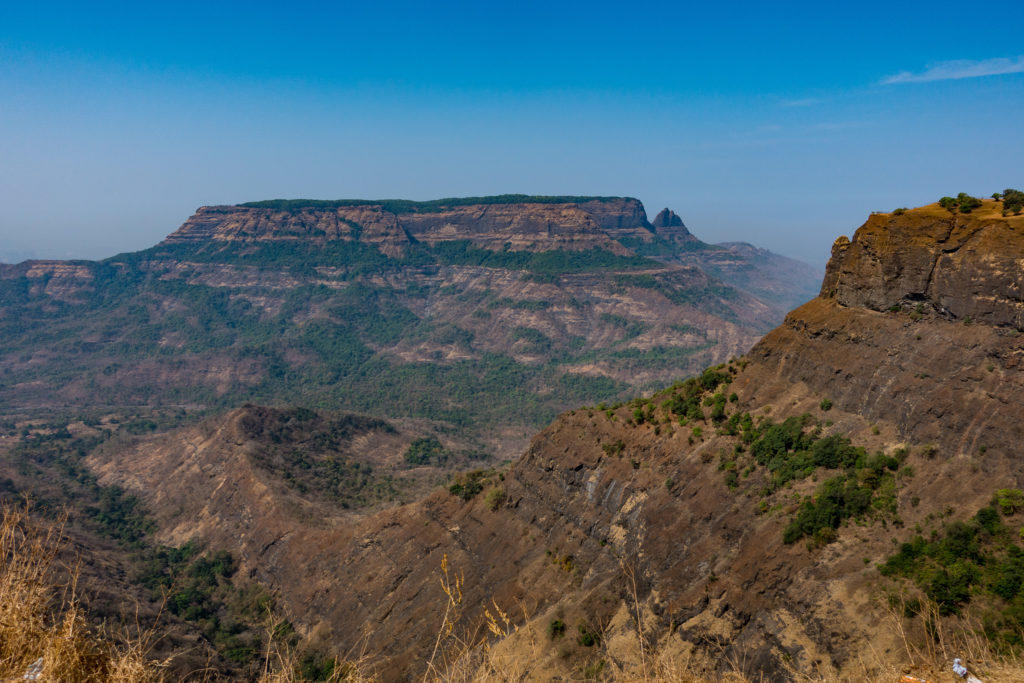
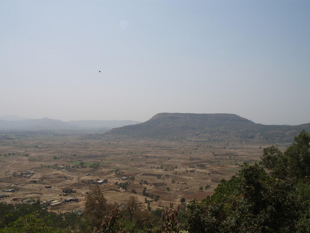
The Deccan Plateau in India is a volcanic landform created by the buildup of basaltic lava.
Intermontane plateaus are generated as a result of tectonic activity and the upward movement of the Earth's crust. They are located between mountain ranges.
The Tibetan Plateau, also known as the "Roof of the World," is a plateau located between the Himalayas and other mountain ranges.
Piedmont plateaus are created in the foothills of mountains via the deposition of sediments carried down from the highlands.
The Appalachian Piedmont in the eastern United States is a plateau characterized by its piedmont topography.
Lava plateaus are generated when lava accumulates and solidifies, similar to volcanic plateaus. However, lava plateaus are often flatter in comparison.
The Columbia Plateau in the northwestern United States is a large flat area created by the widespread movement of molten basaltic lava.
Dome-shaped plateaus are created by the upliftment of extensive, geologically stable regions, often consisting of durable rocks. The Colorado Plateau showcases geologic formations characterized by dome-shaped structures.
Submarine plateaus are formed beneath the sea and often represent relics of former continental shelves.
The Sargasso Sea, located in the North Atlantic Ocean, has a submerged plateau.
Polar plateaus are located near the Earth's poles and are characterized by a covering of ice and snow. The Antarctic Plateau, housing the East Antarctic Ice Sheet, is an example of a polar plateau.
Peninsular Plateau of India
The Peninsular Plateau of India, also known as the Indian Peninsular Plateau, is a flat tableland located in the southern part of the country, surrounded by the oceans on three sides. It is one of the five physiographic divisions of India and is the oldest and largest landmass in the country.
The Peninsular Plateau of India, also known as the Deccan Plateau, one of the country's defining physical features, is a level tableland located in the southern region of India, bordered by the seas on three sides. It is one of the five physiographic divisions of India. In addition to being the oldest landmass in the world, it is also the biggest physiographic division in the world.
The Deccan Plateau is historically and geographically significant. Its central location has been a cultural and commerce hub throughout history, shaping the subcontinent.
Characteristics of the Peninsular Plateau of India
| Feature | Description |
| Shape | The almost rectangular Deccan Plateau is situated along the southern boundary of the Indo-Gangetic Plains. From this point, it gradually slopes downward till reaching Kanyakumari. |
| Area and Extent | The extent of the region is defined by an irregular line that starts from Kutch and follows the western side of the Aravalis until it reaches places near Delhi. From there, it runs roughly parallel to the Yamuna and Ganga rivers, extending up to the Rajmahal Hills and the Ganga Delta. The Peninsular India, which is the biggest physiographic unit in India, measures approximately 16 lakh square kilometers, or, almost half of the country's total area. |
| Boundaries | The region is encompassed by hill ranges on three sides. To the north, it is delimited by the Aravali Range, the Vindhya, the Satpura, the Bharmer, and the Rajmahal Hills. The Western Ghats serve as the western boundary. To the east, it is delimited by the Eastern Ghats. |
| Composition | This ancient tabular block is composed of schists and has an Archaean origin. It is considered to be a stable barrier that has undergone few structural modifications after its initial formation. |
| Drainage | The Peninsular Plateau exhibits a mostly west-to-east slope. The primary cause for the west-east flow of the main peninsular rivers (except Narmada and Tapi) is their drainage into the Bay of Bengal. |
| Elevation | The average height of the Deccan plateau is 600 meters above the ocean's surface. The tallest point is Doddabetta Peak in Tamil Nadu, which reaches an elevation of 2637 meters. |
Plateaus of India (By State)
| Plateau Name | State |
| Deccan Plateau | Telangana, Maharashtra, Andhra Pradesh, Karnataka, Kerala, Tamil Nadu, Odisha (part), Madhya Pradesh |
| Central Highlands | Madhya Pradesh, Maharashtra, Chhattisgarh, Rajasthan |
| Chotanagpur Plateau | Jharkhand, Odisha, Chhattisgarh |
| Meghalaya Plateau | The seven states of Northeast India |
| Marwar Plateau | Western Rajasthan |
| Bundelkhand Upland | Uttar Pradesh, Madhya Pradesh |
| Malwa Plateau | Madhya Pradesh, Rajasthan |
| Baghelkhand | Madhya Pradesh, Uttar Pradesh |
| Aravalli Range (plateau Section) | Rajasthan, Gujarat |
| Chotanagpur Plateau Extension | West Bengal, Bihar |
| Shillong Plateau (Meghalaya) Sub-plateaus | Meghalaya |
| Deccan Plateau Sub-plateaus | Maharashtra, Kerala |
The Marwar Upland is situated to the east of the Aravali Range, which is why it is also referred to as the Upland of Eastern Rajasthan.
The average elevation of this part of the Indian Peninsular Plateau ranges from 250 to 500 meters, and it slopes eastwards.
The Central Highlands (Madhya Bharat Pathar) are located to the east of the Marwar Upland, with most of the region situated within the Chambal River Basin.
The Bundelkhand Upland is a region bounded by the Yamuna River to the north, Madhya Bharat Pathar to the west, Vindhyan Scarplands to the east and southeast, and Malwa Plateau to the south.
It spans the border between Uttar Pradesh and Madhya Pradesh, with an average elevation of 300-600 meters above sea level, sloping down from the Vindhyan Scarp toward the Yamuna River.
The Malwa Plateau is a triangular-shaped plateau, with its base lying on the Vindhyan Hills in the north and bounded by the Aravali Range in the west and Bundelkhand in the east. It constitutes an extension of the Deccan Traps.
The general height of the plateau is 600 m in the south, which decreases to 500m in the north.
The Baghelkhand region is located to the east of the Maikal Range, bounded by the Son River to the north and anticlinal highlands and synclinal valleys composed of sandstones and limestones to the south.
The region has an elevation ranging from 150 meters to 1200 meters.
The Chotanagpur Plateau is located to the east of the Baghelkhand Plateau and represents the north-eastern extension of the Peninsular Plateau of India. The plateau spans across the border regions of Jharkhand, northern Chhattisgarh, and the western part of West Bengal.
The average height of the plateau is 700m above sea level.
The Hazaribagh Plateau is located north of the Damodar River and consists of isolated hills, including the Parasnath hills. Despite being a plateau, it resembles a peneplain due to extensive erosion.
The Ranchi Plateau lies south of the Damodar Valley and has a rolling surface with some areas interrupted by monadnocks and conical hills. The western part of this plateau includes Pats and Mesas, which are high areas capped with laterite.
The Rajmahal Hills are situated at the northeastern edge of the Chhotanagpur plateau and are primarily composed of basaltic lava.
The Meghalaya Plateau, also known as the Shillong Plateau, is located in the northeastern region of India. It is bordered by the Brahmaputra Valley to the north and the Surma and Meghna Valleys to the south.
The Deccan Plateau is a triangular-shaped plateau bounded by the Satpura and Vindhya ranges in the northwest, the Mahadev and Maikal ranges in the north, the Western Ghats in the west, and the Eastern Ghats in the east.
Covering an area of approximately 500,000 square kilometers, it is the largest unit of the Indian Peninsular Plateau.
The Maharashtra Plateau is situated in the state of Maharashtra and constitutes the northern section of the Deccan Plateau. The landscape appears as a gently undulating plain due to weathering processes. The presence of horizontal layers of solidified lava has resulted in the characteristic Deccan Trap topography.
The Chhattisgarh Plain is a saucer-shaped depression drained by the upper stretch of the Mahanadi River. The entire basin is situated between the Hills of Odisha and the Maikala Range, and is laid with nearly horizontal beds of limestone and shales.
Ecological Structure of the Deccan Plateau
The general meaning of geologic structure refers to the study of the distribution and types of rock on the surface and inside the surface. The Deccan plateau can be divided into the following geologic structures:
Archaean Rock (4.5 Billion to 2.5 Billion years)
The oldest rock formation on Earth, found in Kerala, Tamil Nadu, Andhra Pradesh, and Telangana, with no signs of fossils.
Dharwar Rocks (2.5 Billion to 1.8 Billion years)
The earliest sedimentary rock, mainly found in Karnataka, and also present in Madhya Pradesh, Jharkhand, Aravali, and Meghalaya.
Cuddapha Rocks (1.8 Billion to 540 million years)
Found in the Nallamalai hills of Andhra Pradesh and Telangana.
Gondwana Rocks (400 Million to 200 Million years)
Accounting for about 98% of Indian rocks, found in the Mahanadi and Godawari regions of the Deccan plateau, as well as in the Chhotanagpur and Meghalaya plateau.
Deccan Trap (80 to 66 Million years)
A basaltic volcanic formation spread across Maharashtra, Gujarat, Madhya Pradesh, Karnataka, and Telangana.
Importance of the Deccan Plateau
The Peninsular Plateau of India has great importance as it is the oldest and most geologically stable region in the Indian subcontinent.
Minerals: The plateau possesses abundant mineral resources such as iron, copper, manganese, bauxite, chromium, mica, gold, and more.
Coal: The area is home to 98 percent of the Gondwana coal resources in the country.
Agriculture: The region is characterized by the presence of fertile black soil, which is well-suited for cultivating a variety of crops including cotton, tea, coffee, rubber, millet, and more.
Forest produce: These places are rich in forests and serve as a plentiful supply of lumber and other forest resources.
Drainage: The rivers in these regions have excellent prospects for hydroelectric power generation and serve as a source of irrigation for agricultural purposes.
Tourism: The location boasts a plethora of picturesque destinations, including Ooty, Pachmarhi, Kodaikanal, Mahabaleshwar, Mount Abu, and more.
Discover who won what in the recently-concluded Lok Sabha elections in India, if you want to know more about the Political map of India after Elections 2024.
Major Plateaus of the World
| Name of the Plateau | Location | Area (km²) | Minerals |
| Tibetan Plateau | Tibet, China | 2,500,000 | Gold, copper, lead, zinc |
| Deccan Plateau | India | 1,000,000 | Coal, iron ore, manganese |
| Patagonian Plateau | Argentina, Chile | 240,000 | Petroleum, natural gas |
| Brazilian Highlands | Brazil | 2,000,000 | Gold, iron, manganese |
| Mexican Plateau | Mexico | 590,000 | Silver, copper, lead, zinc |
| Columbia Plateau | USA | 208,000 | Basalt, sand, gravel |
| Colorado Plateau | USA | 337,000 | Uranium, coal, copper, oil |
| Altiplano Plateau | Bolivia, Peru | 200,000 | Copper, gold, silver, tin |
| Adamawa Plateau | Nigeria, Cameroon | 64,000 | Tin, limestone |
| Ethiopian Plateau | Ethiopia, Eritrea | 236,000 | Salt, gold, potash |
The Tibetan Plateau, known as the "Roof of the World", is the highest and most extensive plateau on the planet, spanning over 2.5 million square kilometers. Its vast expanses of grasslands, snow-covered peaks like Mount Everest, and distinctive cultural heritage make it a truly remarkable and captivating destination.
Significance of Plateaus in India
The plateaus in India are rich in natural resources, contributing to the country's uniqueness, especially in its geographic and biological variety.
Mineral Deposits
Plateaus have the largest proportion of minerals found in the world. Plateaus facilitate the collection of minerals more easily compared to mountains. Plateaus are the primary source of raw materials used in industry. The Chottanagpur Plateau in India is rich in mica, iron, coal, and several other metals.
Hydropower Generation
Plateau margins, which bear a resemblance to waterfalls, are ideal sites for generating hydroelectric power. The Koyna Hydroelectric Project is India's largest fully operational hydroelectric power project, boasting a generating output of 1960 MW. The Shivanasamudra Hydroelectric Power Plant is the first power station in India located on the Kaveri River in Karnataka.
Agribusiness and Livestock Farming
Plateaus with extensive grasslands provide optimal conditions for raising livestock, particularly sheep, goats, and cattle. Due to their high fertility and mineral content, lava plateaus are utilized for agricultural purposes. The presence of iron in the peninsular plateau of India contributes to its abundance of black soil, which is known for its fertility and suitability for agriculture.
India is blessed with abundant resources and facilities to be the best country in the world, plateaus are one of the many useful geographical features we have been blessed with!
Summarise with AI:
Enjoyed this article? Leave a rating!


